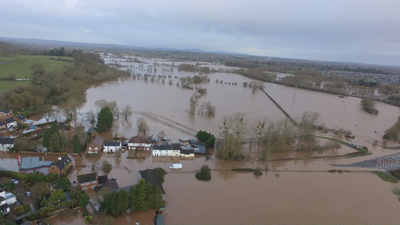
A close up look at the February 2020 Worcester Floods


https://www.facebook.com/greenlibdems/posts/3905322122818982I'm sat here writing this on Tuesday the 18th of February 2020 as my account of the impact of flooding on Worcester as I have seen it, living on the St John's (western) side of the River.
To give a little bit of background I live in a modest flat in a converted merchants town house which overlooks the River Severn and the Pitchcroft Racecourse which I moved into in 2011. I have always felt very lucky to live here, but never quite so grateful as now, given that the building I live in is well above the river levels brought by the flooding. This has obviously given me an excellent vantage point to observe the river and racecourse which is, in reality, a flood plain used most of the time for leisure activities including our annual beet festival, circuses and other activities as well as racing.
Over the course of recent months we have had floods in October, November, December, January and now, with Storm Dennis. Previously Worcester had been hit by severe floods in 2007 and 2014 which had prompted Worcestershire County Council to put £1.2 million into improving flood defences on the New Road section of the A44 between Cripplegate Park and Worcestershire County Cricket Club. Residents had objected to the felling of trees along the road which were removed to complete works at the time. But with the severity of the floods with recent storms even these improved defences have now failed.
The floods of course make for dramatic pictures and news reports, but it's only by visiting affected areas that you really start to get a detailed assessment of the impact they bring locally. One of Worcester's main road arteries the A443 Hylton Road, which runs along the river and past both the Worcester news and BBC Hereford & Worcester buildings, shuts whenever the river breaches it's banks to any real extent. Normally raised banking on which a footpath runs and pumps installed for these occasions by the Worcester Arena keep the road reflexively dry, but it's not unusual for it to be closed to most traffic as a precaution.
Diversions take traffic from the Worcester University junction along the B4206 Henwick Road into the centre of St Johns, meeting up with the A44 Bromyard Road, a spot known as The Bullring which is notorious for heavy traffic on the best of days. Descending down the hill the combined A443 and A44 Traffic merges with traffic from a third major artery into the city the A449 Bromwich Road. The resulting traffic combines on a one way system around Cripplegate Park that effectively forms a roundabout before taking traffic across the historic and strategic Worcester bridge. Taking all this into account it's easy to see how the net effect of the flooding on Monday was to cut these three major road arteries off from the city centre.
The nearest river crossings for road traffic were the Carrington Bridge to the South which a one way system had been imposed and the bridge at Holt Fleet to the North. All of which combined caused severe problems for traffic.
Homes and Businesses along the river were also affected. As aerial shots taken from drones and Helicopters show the pitch at Worcestershire County Cricket Club and half of Cripplegate Park by the Bridge were under water. Even the new £1.2 million flood defences on New Road had failed with water coming up Tybridge almost surrounding the park.
The popular Hickory's restaurant next to the park was cut off as were ALDI, The Range, and McDonalds on the Hylton Road Retail Park. The A443 Hylton road itself was flooded worse than I have ever seen before,
with the pumps and river bank having completely failed. Worcester News, BBC Hereford & Worcester, Worcester University's the Arena, and businesses along the road were cut off to traffic, only a few businesses had access at the rear of the buildings via a footpath from Henwick Road. Terrace houses facing onto the road looked to be the worst affected though with water coming right up to some properties.
Beyond the Hylton road area is a pathway that runs along the river normally used by walkers and bicyclists for leisure. This is of course now completely flooded, hedges and gardens almost completely under water.
This path runs down to and beyond Ferry Bank, a footpath down from Henwick Road above with houses at the bottom. One hose was surrounded by flood water. Further down the river is the bottom of King Stephen's Mount, where houses were a bit luckier, being raised just above the flood waters only their gardens and in one case a driveway was flooded. Looking to the future it's clear that local authorities will need to do a lot more to adapt to our changing climate. Worcester City Council was the first of the counties local authorities to declare a climate emergency which it has set a target date of 2030 to go carbon neutral by. I attended a public meeting of the cross party Environment Committee on the 28th of January on which Liberal Democrat Councillor Mel Allcott sits.
On that night they voted unanimously to adopt a draft Environmental Sustainability Strategy for the City of Worcester for 2020-2030 along with an annual budget of £100,000.
By contrast Worcestershire County Council rejected a call to declare a climate emergency.
It is my sincere hope that in the light of the severe floods and the failure of the County Councils own flood defences that our City Council will be able to take the lead and work with the other local authorities to to take our climate emergency more seriously in the future.

Please join our online discussion of this article

